Crystal Clear Natural Springs
Here are some of the springs through out the small towns of Crystal River and Homosassa Springs, as well as the Rainbow River and Springs, located in the town of Dunnellon.
Tarpon Spring, "aka" Crystal Spring or King's Spring is sub-aqueous and is located on the south side of Banana Island.
One of the finest freshwater dive sites in the state.
Excellent visibility, size, convenience of access and its potential for underwater photography.
Tarpon Spring is about 65 ft deep and 200 ft in diameter.
An adjacent spring to it's east is reported to have a more vigorous flow.
Although in the caves lights are useful to look around, some swim with out and let their eyes adjust. The underwater scene is wonderful, as there are often hundreds of fish schooling within the two exits.
Homosassa Springs
Kimberlee L. Tennille, Park Manager
Ellie Schiller Homosassa Springs Wildlife State Park
4150 S. Suncoast Blvd. (hwy #19), Homosassa, FL 34446
coordinates:
Latitude: 28.7994274
Longitude: -82.5875998
TripAdvisor reviews
Crystal Springs
Crystal River, East side of King's Bay.
coordinates:
Latitude: 28.8905351
Longitude: -82.5923232
TripAdvisor reviews
Hunter Springs Park
104 NE 1st Ave., Crystal River, FL 34429
Amenities:
Pavilion with restrooms, Picnic area with BBQ grills, Small grass beach area on the Crystal River, Kayak launch, Sand volleyball court.Hunters Spring park is a small park with soft grass beach.
Water is crystal clear with white sand and partial grass bottom, perfect for snorkeling, and though not every day, you might experience a manatee encounter.
Entry is Free.
Sorry, No Pets.
TripAdvisor reviews
American Legion Spring
It is beneath a diving board at a public beach on Hunter Spring Run, at the south edge of Crystal River. It has free parking and access.
Gator Hole may also be known as Magnolia Spring or Crystal Spring
It is about 0.5 mi. S. of Crystal River.Gator Hole is reported to have had rock spires and an extensive cave system that collapsed about 1963.
Crab Creek Springs
Part of the Chassawitska.
From Homosassa Springs Wildlife State Park, drive south on US 19/98 5.8 miles.
Turn west (right) on CR 480 and drive about 1.8 miles to the public boat access area.
Crab Spring Run enters the north side of the Chassahowitzka River 400 ft downstream from the Chassahowitzka boat ramp.
Crab Spring is at the head of the run.
Wildlife abundant, be alert for this is including the occasional predator.
This dive site is definitely a cave dive, do not attempt to go there before you have done cave training and be sure to bring enough equipment.
Crab Creek Springs Private Dock:
N28.43.026'W82.34.555'
Baird Creek Entrance Sand Bank:
N28.42.875'W82.35.066'
Idiots Delight
A group of three vertical shafts at least 20 ft in depth, the largest being 5 ft in diameter.
Idiots Delight is about 0.25 mi. SE. of Gator Hole on the east side of Kings Bay.
Three Sisters Springs
Also known as Middle Springs, is a few hundred feet north of Idiots Delight.
This spring is a favorite to many.
Crystal River, east side of King's Bay.
coordinates:
28.888725°N82.589191°W.
TripAdvisor reviews
Shark Sink
On the west side of the Bay.
It reportedly developed when its roof suddenly collapsed about 1905.
Shark Sink is 45 to 48 ft deep.
Rainbow Springs State Park
(In the city of Dunnellon)
*Campground on premises
19158 S.W. 81st Place Road, Dunnellon, FL 34432
There are no manatees here, but so much more to do then most any other spring.
30 minutes from Crystal River.
Some local kayak renters & outfitter's offer a shuttle.
Ph.: 352-465-8555
TripAdvisor reviews
Chassahowitzka River and NWR
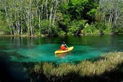
Self Guided Kayak Tour
Kayaking difficulty is moderate.
The scenery is photo-worthy.
Located in Homosassa, FL.
The self guided tour listed below is a 7 mile multi-spring round-trip.
Description
Chassahowitzka, pronounced "Chaz-wits-kuh", consists of a series of freshwater springs; river branches and a U.S. National Wildlife Refuge (NWR).
Located 60 miles north of Tampa on the gulf coast of Florida, the 31,000+ acre refuge was created in 1943 as a winter preserve for migratory waterfowl.
Along with waterfowl, a canoeist or kayaker can spot manatee, raccoons, otters, alligators and possibly deer, coyote, bobcat or even a Florida panther or black bear.
The headwaters of the river start approximately 100 feet upstream from the Chassahowitzka River Campground's boat ramp.
A first magnitude spring and smaller 2nd magnitude springs in the area create the river which flows 7 miles west to the Gulf of Mexico.
The wildlife refuge starts three miles downstream from the campground.
The northern boundary of the NWR parallels the Homosassa River, with the southern end 12 miles south at Raccoon Point.
Access to the National Wildlife Refuge is by boat only with the best launch for paddlers at the campground.
Camping is prohibited in the NWR, but available at the Chassahowitzka River Campground.
The campground features RV and primitive (tent) camp sites, a general store, showers, restrooms, telephone and a boat launch.
Access From Weeki Wachee
Take US-19 north 13 miles to CR 480 (Miss Maggie Drive).
Go west (left) on 480 for approximately 1.5 miles to Chassahowitzka River Campground.
Follow signs to boat launch. Be sure to ask for a canoe map when you pay the parking fee.
Important Items
WATER, Food, Boat, Paddle, PFD (flotation device), Chassahowitzka Parking Fee, Map, Compass, Insect Repellent, GPS,
Kayak and Canoe rentals available.
Environment National Wildlife Refuge.
First and Second Magnitude Springs.
Brackish Water, Lowland Swamps, Saltwater Bays, Estuaries, Tidal Marshes, Palm, Ferns, Saw-grass, many Birds, Reptiles, Amphibians and Mammals.
The Tours
Tour #1: The Springs Loop (7 miles):
The Springs Loop will take you through seven of the more easily accessible springs along the Chassahowitzka River.
If you make the trip on a weekday, you'll probably have most of the springs and river to yourself, but on weekends plan on sharing these wonderful springs with a few boaters (both paddle and motorboat variety).
Arrive early in the day to have a parking space at the campground.
Please note that some of these springs are located in remote, deep woods areas.
You should be comfortable with using a map, compass, GPS or other navigational tool prior to making the trip.
The Beginning:
Chassahowitzka Springs:
To begin, put-in at the campground's boat ramp.
Paddle 100 feet upstream (east).
Congratulations, you've made it to the Main spring.
The opening to the spring is about 20-30 feet deep in the upper portion of the basin.
Swimming and diving are prohibited at this location due to motorboat traffic.
Unnamed Springs:
The next set of springs can be found just a few hundred feet to the east of the main spring.
Enter the man made channel (left as you are paddling east), and go about 75 feet.
The spring run is between 1 and 2 feet deep in most places, so it's easy to exit your boat for photos or a quick swim.
Water flowing from the springs is clear and appears to be a radiant blue when viewed in direct sunlight.
By paddling the length of the spring run, you should be able to spot 8+ different vents feeding these springs.
Crab Creek Springs:
Starting at Unnamed Springs, head downstream about 200 yards past the boat ramp.
The entrance to Crab Creek is located on the north side of the river.
The spring run is jungle-like and 100 yards in length.
You'll see two beautiful homes immediately adjacent to the springs.
You can visit the springs, but all surrounding land is private property, and the water is full of particulate matter as well as being 6 to 8 feet deep, so be weary leaving your kayak.
You'll see a light blue color at the three spring vents.
Blue Springs - *Baird Creek:
From Crab Creek Springs, head downstream and paddle along the Chassahowitzka River for approximately 1/2 mile then turn south (left) to Baird Creek.
You can identify the entrance by a tiny island, complete with palm trees, marking the pathway.
Baird Creek is a narrow, shallow (1-2 feet deep), twisty, jungle-like waterway enclosed by saw-grass and trees.
If you are terrified of the possibility of running into alligators, snakes or swarms of mosquitoes you might want to skip Blue Springs and The Crack.
For those brave enough to continue on, slap on generous amounts of insect repellent and start the 1/2 mile paddle to the springs.
This tiny partially canopied waterway offers some tremendous photo and wildlife viewing opportunities.
Blue Spring forms a small lagoon, about 100 feet in diameter.
The water is a dark, cloudy blue so it's not possible to see the bottom.
Much of the pool is surrounded by saw-grass and trees, but you can dock along the back end of the pool for either a quick dip or well-deserved break.
The Crack - *Baird Creek
The entrance to the Crack can be found at the back end of Blue Springs.
Look for a small opening between two large palm trees.
The waterway here, like much of Baird Creek, is narrow and shallow.
Pass the two small turquoise-colored pools and continue upstream until the water becomes too shallow to paddle.
You'll need to exit your boat and hike the remaining 200 feet through ankle deep water to the spring.
The Crack is a jagged crevice about 30 feet long.
The clear, oval shaped pool is less than one foot deep and surrounded by forest.
The mosquitoes will keep you from spending too much time in the area.
To return to the Chassahowitzka River, hike and paddle downstream to Blue Springs.
Enter Baird Creek, paddle 1/2 mile back to the river.
Salt Springs - Salt Creek:
After returning to the main channel, paddle downstream for 1/3 mile.
Here you will encounter a large island that divides the river.
The south (left) fork is used by powerboats.
The right fork is shallower and provides a route much less traveled.
Take the right fork and paddle in a northwest direction for approximately 1/4 mile to the "T" intersection that signals the entrance to Salt Creek (to the north/right) and the main channel of the Chassahowitzka (south/left).
Salt Creek is fed by several streams which look a-like, so it's easy to get lost in this area.
Be sure to carefully chart, or better yet, use a GPS to map your route.
At approximately 1/5 mile from the entrance, a small creek will run directly north.
Stay to the right to keep on Salt Creek.
If you pass a tree growing in an upside down "U" shape, you're on Salt Creek.
The upper branches of the tree are partially blocking the creek so it's easy to spot.
Salt Creek narrows considerably and heads southeast to a large spring-fed lagoon.
After a rest stop, carefully retrace your route back to the entrance of Salt Creek.
Paddle 200 yards southwest to the main channel of the Chassahowitzka.
Turn downstream to continue to Potter Creek.
Potter Springs - Potter Creek:
Just west of where Salt Creek meets the river, the Chassahowitzka widens and becomes shallow.
You'll see old posts sticking up from the river bed.
These were once part of an old railroad trestle crossing the river.
Another 1/4 mile paddle downstream will bring you to the entrance of Potter Creek, located on the north side of the river.
Potter Creek runs almost directly north for approximately 3/4 mile to the spring head.
The creek is 30-50 feet wide in most places so it's easy to navigate.
The spring itself is about 100 feet across.
A very shallow creek flows into Potter Spring from the north, with Ruth Spring as its source.
If you are extremely adventurous, you can paddle and hike 300 feet up the narrow creek to Ruth Spring.
Be careful as this is truly a wild place and you will almost certainly come across alligators, snakes, spiders and more.
Warning, Please Read:
Some of the springs listed above have cave systems to explore, and though some are extremely safe, a few are rated at an expert level.
Be sure to know what you are diving in to before diving in to it.
Cave systems have continuing "cave-ins" closing passages, and sometimes opening up new ones.
Please research any caves before any dives, and never cave dive alone.
Most if not all of these caves have caused lost of lives, including many open water divers.
Many of the sites listed here are shore or inland dives and some are on private or posted property. Please be sure to ask the owners for permission before diving.
Some sites are open only to permitted persons or groups or are on the verge of being closed due to liability concerns, trash or property damage (Usually caused by non-divers).
For further information regarding any local springs, contact any local dive shops or tour companies.
